基于点线面混合控制基元的点云地理化  下载: 626次
Point Cloud Georeferencing Based on Fixed Control Primitives of Point, Line, and Surface
1 山东理工大学建筑工程学院, 山东 淄博 255049
2 中勘天成(北京)科技有限公司, 北京 100097
图 & 表
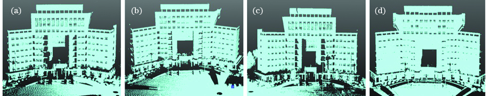
图 1. 扫描的点云。(a) S1;(b) S2;(c) S3;(d) S4
Fig. 1. Point cloud obtained by scanning. (a) S1; (b) S2; (c) S3; (d) S4
下载图片 查看原文
图 2. 两种地理化方法的误差。(a)平面点位误差;(b)空间点位误差
Fig. 2. Errors of two geography methods. (a) Error of the plane point; (b) error of the spatial point
下载图片 查看原文
图 3. 地理化点云的目视效果
Fig. 3. Visual effect of the georeferencing point cloud
下载图片 查看原文
表 1地面控制点的坐标及精度
Table1. Coordinates and accuracies of ground control points
| Point number | North coordinate /m | East coordinate /m | Elevation /m | Planar point position error /mm | Elevation error /mm |
|---|
| K1 | 5495.4386 | 8218.0336 | 37.2285 | 1.36 | 0.209 | | K2 | 5525.7044 | 8112.3495 | 37.1517 | 1.52 | 0.315 | | K3 | 5477.9588 | 8189.2281 | 37.9380 | 1.04 | 0.161 | | K4 | 5368.6824 | 8165.1235 | 37.2274 | 2.07 | 0.217 |
|
查看原文
表 2地理参考坐标系下控制基元的特征参数
Table2. Characteristic parameters of the control primitives in the geographic reference coordinate system
| Primitive category | Primitive number | Primitive characteristic parameter |
|---|
| X | Y | Z |
|---|
| Control point | K1/m | 5495.4386 | 8218.0336 | 38.7994 | | K2/m | 5525.7044 | 8112.3495 | 38.7681 | | K3/m | 5477.9588 | 8189.2281 | 39.4380 | | K4/m | 5368.6824 | 8165.1235 | 38.7274 | | Control line | L1 | 0.00127295 | 0.00035120 | 0.99999913 | | L2 | -0.00298367 | 0.00017343 | 0.99999553 | | Control plane | P1 | 0.10908025 | 0.99403020 | -0.00233792 | | P2 | -0.40381974 | 0.91483312 | 0.00315886 | | P3 | 0.99387286 | -0.11052110 | 0.00134817 |
|
查看原文
表 3扫描坐标系下各站控制基元的特征参数
Table3. Characteristic parameters of the control primitives of each station in the scanning coordinate system
| Scan station | Primitive number | Primitive characteristic parameter |
|---|
| X | Y | Z |
|---|
| S1 | K1'/m | 24.1957 | -27.3355 | -0.9703 | | K2'/m | -36.6460 | 64.1949 | 2.1386 | | K3'/m | -3.3906 | 58.8066 | 2.4820 | | L1' | 0.00291538 | -0.03029386 | 0.99953678 | | P2' | 0.28538658 | 0.95806159 | 0.02593249 | | S2 | K1'/m | 39.0932 | 98.8350 | -0.8236 | | K2'/m | -3.3451 | -2.5881 | 3.7250 | | K4'/m | -122.9577 | 64.8070 | 2.482 | | L2' | 0.03001756 | -0.00074751 | 0.99954909 | | P1' | 0.97409640 | -0.22370053 | -0.03307980 | | S3 | K2'/m | -28.0789 | -49.9781 | -0.5254 | | K3'/m | 37.2946 | 12.6000 | 1.1517 | | K4'/m | 137.1247 | -37.9807 | 1.9611 | | L2' | -0.01497985 | 0.00140723 | 0.99988681 | | P3' | 0.35472909 | 0.93494524 | 0.00668375 |
|
查看原文
表 4两种地理化方法的地理化参数
Table4. Geographical parameters of two geographic methods
| Scan station | Geographicmethod | XS /m | YS /m | ZS /m | φ /(°) | ω /(°) | κ /(°) |
|---|
| S1 | method1 | 5148.4953 | 8520.5665 | 38.8158 | -1.1155 | 1.1393 | 220.2606 | | method2 | 5148.4966 | 8520.5660 | 38.8134 | -1.1138 | 1.1407 | 220.2577 | | S2 | method1 | 5194.8133 | 8478.6433 | 39.5442 | -0.0115 | 2.1240 | 272.8248 | | method2 | 5194.8091 | 8478.6463 | 39.5432 | -0.0134 | 2.1316 | 272.8271 | | S3 | method1 | 5167.7385 | 8510.9581 | 38.8667 | -0.2330 | 0.5101 | 104.6584 | | method2 | 5167.7412 | 8510.9603 | 38.8638 | -0.2114 | 0.4851 | 104.6563 |
|
查看原文
表 5两种地理化方法的RMSE
Table5. RMSE of two geography methods
| Scan station | Geographicmethod | XS /m | YS /m | ZS /m | φ /(°) | ω /(°) | κ /(°) |
|---|
| S1 | method1 | 3.0 | 2.9 | 0.4 | 0.0086 | 0.0005 | 0.0036 | | method2 | 2.6 | 2.0 | 1.2 | 0.0047 | 0.0011 | 0.0031 | | S2 | method1 | 4.1 | 3.3 | 1.6 | 0.0045 | 0.0092 | 0.0044 | | method2 | 2.7 | 1.8 | 2.4 | 0.0097 | 0.0068 | 0.0029 | | S3 | method1 | 3.9 | 1.3 | 0.3 | 0.0004 | 0.0044 | 0.0024 | | method2 | 1.4 | 2.1 | 1.1 | 0.0075 | 0.0003 | 0.0015 |
|
查看原文
王家晖, 姚吉利, 赵雪莹, 胡信志, 赵猛. 基于点线面混合控制基元的点云地理化[J]. 激光与光电子学进展, 2021, 58(8): 0828001. Jiahui Wang, Jili Yao, Xueying Zhao, Xinzhi Hu, Meng Zhao. Point Cloud Georeferencing Based on Fixed Control Primitives of Point, Line, and Surface[J]. Laser & Optoelectronics Progress, 2021, 58(8): 0828001.


 PDF全文
PDF全文

