基于空天地内一体化的滑坡监测技术研究  下载: 1525次
Research Review of Landslide Monitoring Methods Based on Integration of Space-Air-Ground-Interior
1 南京大学地球科学与工程学院,江苏 南京 210023
2 华北科技学院(中国煤矿安全技术培训中心)计算机学院北京 101601
图 & 表
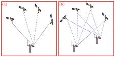
图 1. GNSS监测技术定位方式。(a)绝对定位;(b)相对定位
Fig. 1. Positioning mode of GNSS monitoring technology. (a) Absolute positioning; (b) relative positioning
下载图片 查看原文
图 2. 多效应路径示意
Fig. 2. Multi-effect path schematic
下载图片 查看原文
图 3. SBAS-InSAR技术获得的形变速率图[18]
Fig. 3. Deformation rate map obtained by SBAS-InSAR technique[18]
下载图片 查看原文
图 4. 监测机器人监测原理及数据远程传输示意图
Fig. 4. Schematic diagram of monitoring principle and data remote transmission of monitoring robot
下载图片 查看原文
图 5. 三维激光扫描技术监测滑坡示意图
Fig. 5. Schematic diagram of landslide monitoring by three-dimensional laser scanning technique
下载图片 查看原文
图 6. 三维激光扫描技术滑坡变形监测结果[27]
Fig. 6. Monitoring results of landslide deformation by 3D laser scanning technology[27]
下载图片 查看原文
图 7. TDR监测系统
Fig. 7. TDR monitoring system
下载图片 查看原文
图 8. TDR监测结果[33]。(a)原始数据;(b)差分波形
Fig. 8. TDR monitoring results[33]. (a) Original data; (b) difference waveforms
下载图片 查看原文
图 9. 测斜仪原理
Fig. 9. Principle of inclinometer
下载图片 查看原文
图 10. MEMS测量系统
Fig. 10. Measuring system of MEMS
下载图片 查看原文
图 11. 分布式光纤感测原理图[41]
Fig. 11. Schematic of distributed optical fiber sensing[41]
下载图片 查看原文
图 12. 滑坡多场作用示意图[43]
Fig. 12. Diagram of multi-field action of landslide[43]
下载图片 查看原文
图 13. BOTDA技术监测滑坡变形示意图
Fig. 13. Schematic diagram of monitoring landslide deformation by BOTDA technique
下载图片 查看原文
图 14. 内加热光缆及监测原理。(a)光缆结构示意图;(b)主动加热光纤法原理图
Fig. 14. Internal heating cable and monitoring principle. (a) Structure diagram of cable; (b) schematic of AHFO
下载图片 查看原文
图 15. 分布式光纤测温系统及监测结果。(a)测温光缆;(b)现场监测;(c)分布式测温结果
Fig. 15. Temperature measuring system of distributed optical fiber and monitoring result. (a) Temperature sensing cable; (b) site measuring; (c) distributed temperature measuring results
下载图片 查看原文
表 1空、天监测方法
Table1. Space and air monitoring methods
| Monitoring method | Principle | Advantage | Disadvantage |
|---|
| GNSS | Location of the monitoring station is obtained in real time by satellite | All-weather and whole-time monitoring | Monitoring station selection freedom is low and data processing is complex | | InSAR | Image of landslide is obtained by using SAR satellite, and then the 3D terrain information of landslide is obtained by processing the image | All-weather and whole-time monitoring; high precision | Monitoring point selection is difficult and affected by space loss correlation and atmospheric delay | | UAV | Unmanned aerial vehicle is equipped with a camera, flies and takes pictures according to the designed route, and gets the 3D model of the slope through image data processing | High precision; automation; intelligent; not affected by the clouds | Affected by weather and not all-weather monitoring |
|
查看原文
表 2地表监测主要方法分析
Table2. Analysis of main surface monitoring methods
| Monitoring method | Principle | Advantage | Disadvantage |
|---|
| Robot monitoring | Automatic total station monitors the prisms placed on the landslide in real time | Automatic and whole-time monitoring; high precision | Measuring range of single robot is small, but the cost of multiple measurements is high | | 3D laser scanning | 3D coordinates of the measured object are obtained by measuring the time difference of transmitting and receiving laser and the horizontal angle and zenith distance of each pulse laser | Whole-time, dynamic and initiative monitoring; high precision | Data processing is complex and measuring accuracy is easily affected by surface objects | | GB-InSAR | Ground-based radar sensor moves on the slide track, transmits and receives microwave signals. The synthetic aperture radar technology is used to realize imaging | High precision, all-weather and whole-time monitoring, not affected by weather | Lack of data processing; environment of monitoring can have an impact on results |
|
查看原文
表 3滑坡内部监测技术对比
Table3. Comparison of landslide internal monitoring techniques
| Monitoring method | Principle | Advantage | Disadvantage |
|---|
| TDR | When the coaxial cable is deformed, the echo signal will be reflected back from the deformation. The position and displacement of the deformation can be obtained by collecting the echo signal and analyzing the waveform | Short monitoring time and low cost; accurate sliding surface positioning | Unable to determine the sliding direction; poor sensitivity to uniform deformation; point-type monitoring | | Borehole inclinometer | The probe of inclinometer has a certain angle with the deformation of rock and soil mass, and then horizontal displacement of the inclinometer probe can be calculated using the angle | Monitoring accurately direction of sliding | Point-type monitoring and orientation are susceptible to interference | | Distributed fiber optic sensing | By receiving and analyzing the scattered light, the changes of strain and temperature along the fiber are obtained | High precision; distributed monitoring; high survival rate; corrosion resistance; anti-interference | Unable to determine the sliding direction |
|
查看原文
表 4分布式光纤监测系统多场监测总结
Table4. Summary of multi-field monitoring of distributed optical fiber monitoring system
| Multi-field monitoring | Distributed optical fiber monitoring technology | Principle | Characteristic |
|---|
| Deformation field | BOTDR/BOTDA technology | By measuring the frequency shift of brillouin scattering light, the strain and temperature changes of corresponding points are obtained according to the relationship between the brillouin frequency shift drift amount and the temperature and strain | It is sensitive to temperature and strain, and the true strain can be obtained by temperature compensation | | Temperature field | ROTDR technology | By measuring the ratio of Stokes light intensity and anti-Stokes light intensity in Raman scattered light, the temperature of each part of the optical fiber is obtained | Precision up to several microstrains and sensitive only to temperature | Seepage field | Actively heating technology based on distributed optical fiber temperature measuring system | Through heating optical cable and DTS measuring, the characteristic value of temperature is determined. Then, soil moisture and seepage rate can be obtained according to the characteristic value of temperature | An artificial temperature field is created near the cable, and then obtaining the seepage field |
|
查看原文
徐靓, 程刚, 朱鸿鹄. 基于空天地内一体化的滑坡监测技术研究[J]. 激光与光电子学进展, 2021, 58(9): 0900006. Liang Xu, Gang Cheng, Honghu Zhu. Research Review of Landslide Monitoring Methods Based on Integration of Space-Air-Ground-Interior[J]. Laser & Optoelectronics Progress, 2021, 58(9): 0900006.


 PDF全文
PDF全文

