Shuang Wang 1,2,3,*Jie Zhou 1,2,3Junfeng Jiang 1,2,3,**Kun Liu 1,2,3[ ... ]Tiegen Liu 1,2,3
Author Affiliations
Abstract
1 School of Precision Instrument and Opto-electronics Engineering, Tianjin University, Tianjin 300072, China
2 Key Laboratory of Opto-electronics Information Technology, Ministry of Education, Tianjin 300072, China
3 Tianjin Optical Fiber Sensing Engineering Center, Institute of Optical Fiber Sensing of Tianjin University, Tianjin 300072, China
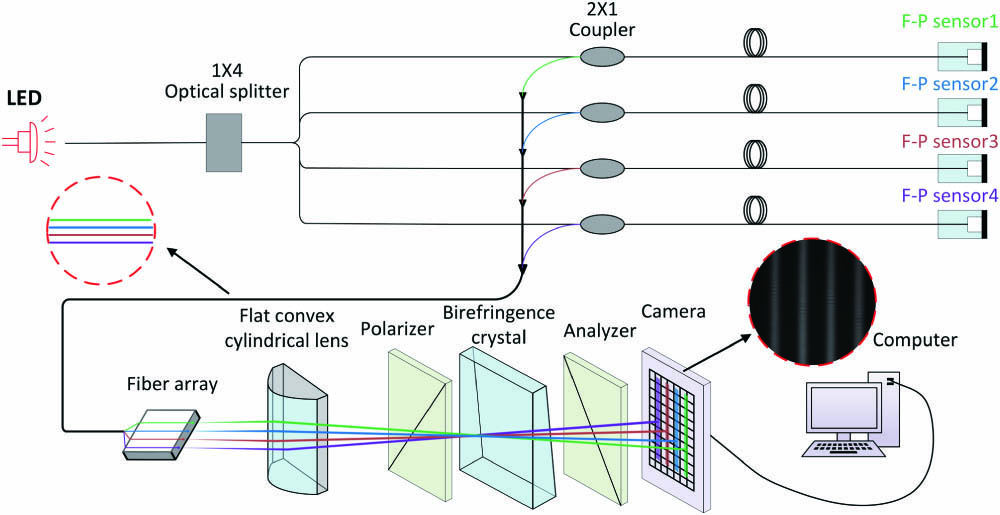
A multi-channel synchronous demodulation system of a polarized low-coherence interferometer (PLCI) based on a matrix charge-coupled-device (CCD) is proposed and demonstrated. By using special designs, the system allows the signals from different channels to be received and demodulated synchronously. Multichannel air pressure experiments were implemented to verify the effectiveness of the proposed system. The experiment results showed that the Fabry–Perot (F–P) sensors could be demodulated synchronously with a high tolerance for light sources and sensors, which indicated that any sensor and light source that can be demodulated by PLCI were allowed to be employed, leading to a wide application in the field of multichannel synchronous measurement.
multi-channel synchronous demodulation polarized low-coherence interferometer matrix charge-coupled-device Fabry–Perot sensors Chinese Optics Letters
2020, 18(7): 071202
1 地理信息工程国家重点实验室, 陕西 西安 710054
2 西安测绘研究所, 陕西 西安 710054
相机参数在轨标定是无地面控制点条件下提高定位精度的关键环节, 利用立体影像进行空中三角测量光束法平差, 是实现相机参数在轨标定的有效途径, 但要保证所建立的航线模型无因姿态变化率而造成的系统变形。本文针对“天绘一号”卫星有效载荷的特点, 采用基于LMCCD影像的EFP光束法平差, 按反解空中三角测量原理进行三线阵相机的重组, 实现对相机参数在轨标定。利用LMCCD影像进行相机参数在轨标定后, 天绘一号卫星无地面控制点条件下定位精度上下视差减小至0.6 pixel。定位精度从9 m提高至7.4 m, 其中高程精度从4.7 m提高至2.7 m, 试验结果表明, 所提方法实现了国内相机在轨标定参数。
卫星摄影测量 在轨标定 LMCCD相机 光束法平差 satellite photogrammetry on-orbit calibration Line-Matrix Charge-Coupled Device(LMCCD) camera bundle adjustment
中国科学院长春光学精密机械与物理研究所,吉林 长春 130033
针对1∶50000比例尺无地面控制点的立体测绘应用和当前卫星姿态测量精度低的问题,采用国际首例的线面阵电荷耦合器件阵列测绘体制,建立了完善的像移补偿模型,设计实现了高强度、高刚度、高稳定度的测绘光学平台,实现了光学平台各相机参数的标定,突破了传输型无地面控制点定位关键技术,满足无地面控制点1∶50000比例尺地图测制,实现了国家基础框架测绘。针对未来更高比例尺的应用需求,提出了双面阵推扫立体测绘成像系统,并针对超级互补金属氧化物半导体面阵传感器应用提出了相关要求,展望了未来的技术发展。
测量 立体测绘 线面阵电荷耦合器件阵列 地面控制点 双面阵推扫成像 光学学报
2015, 35(s1): s112005


