基于离散余弦变换和深度网络的地貌图像分类  下载: 1068次
Landform Image Classification Based on Discrete Cosine Transformation and Deep Network
图 & 表
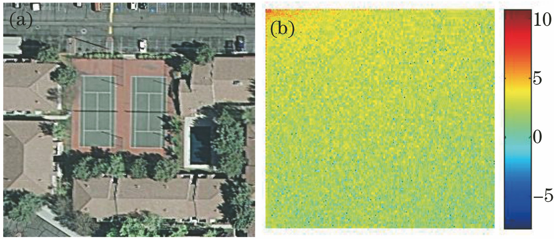
图 1. (a)原图像与(b) DCT后的能量分布
Fig. 1. (a) Original image and (b) energy distribution after DCT
下载图片 查看原文
图 2. CNN结构图
Fig. 2. Structure of CNN
下载图片 查看原文
图 3. 三维频谱图。 (a)原图像DCT系数频谱图;(b)系数选择后的频谱图
Fig. 3. Three-dimensional spectrum diagram. (a) DCT coefficient spectrum of original image; (b) spectrum after the coefficient selection
下载图片 查看原文
图 4. DCT-CNN模型结构
Fig. 4. Structure of DCT-CNN model
下载图片 查看原文
图 5. 基于DCT和深度网络的地貌图像分类算法流程图
Fig. 5. Flow chart of landform image classification algorithm based on DCT and deep network
下载图片 查看原文
图 6. 数据库示例图像。 (a) UC Merced LU数据库;(b)无人机着陆地貌数据库
Fig. 6. Example images in database. (a) UC Merced LU database; (b) UAV landing landform database
下载图片 查看原文
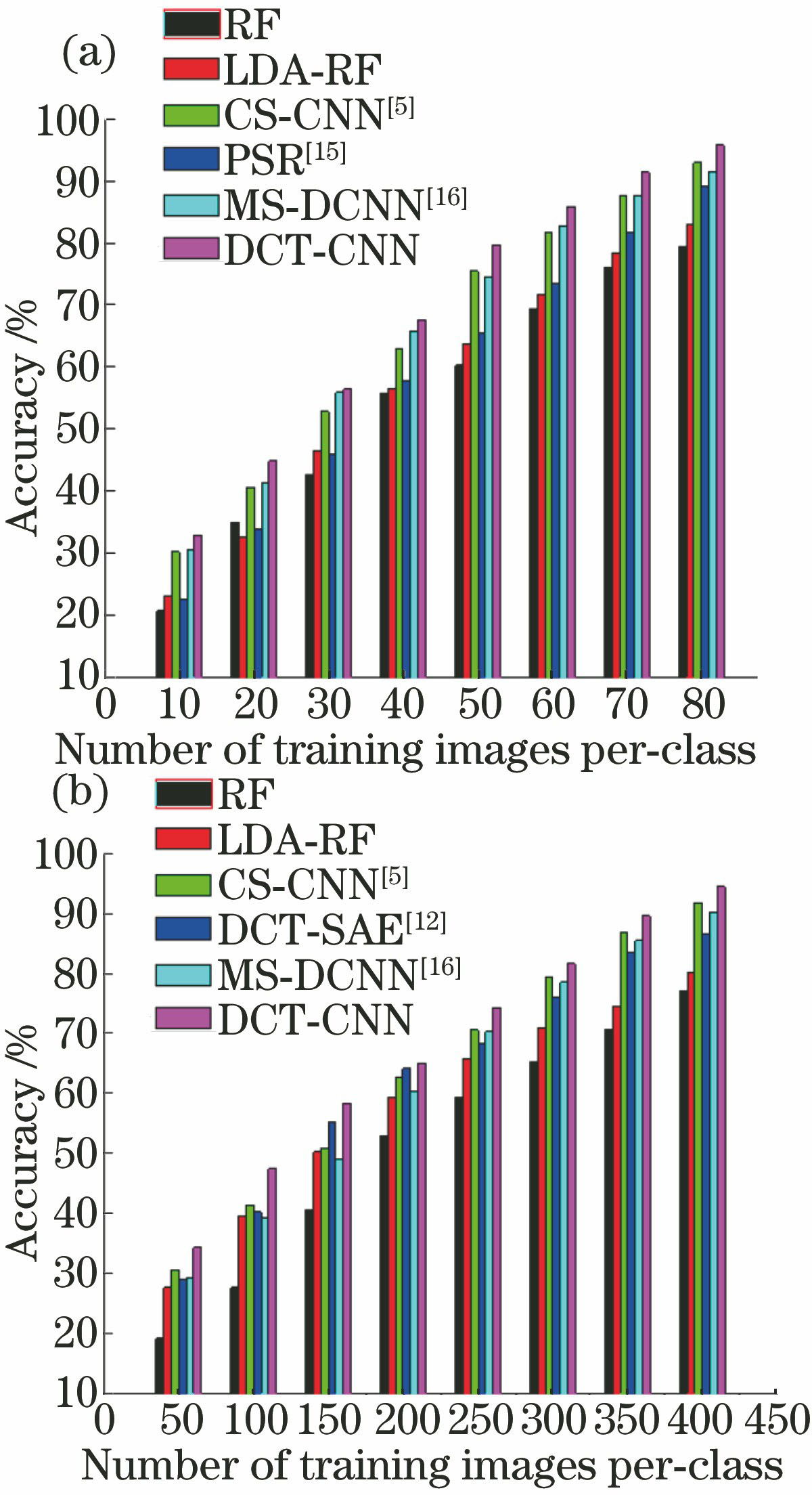
图 7. 训练样本数量不同时各分类方法的分类性能。(a) UC Merced LU数据库; (b)无人机着陆地貌数据库
Fig. 7. Classification performance of each method when the number of training samples is different. (a) UC Merced LU database; (b) UAV landing landform database
下载图片 查看原文
图 8. 无人机着陆地貌数据库图像分类混淆矩阵
Fig. 8. Image classification confusion matrix for UAV landing landform database
下载图片 查看原文
表 1DCT-CNN网络结构的各层参数
Table1. Layer parameters of DCT-CNN network structure
| Layer | Type | Patch size | Stride | Zero padding | Output size |
|---|
| x | Input | | | | 128×128 | | h1 | Convolution | 5×5 | 1 | 2 | 128×128×32 | | h2 | ReLU | | | | | | h3 | Mean pooling | 3×3 | 2 | | 64×64 | | h4 | Convolution | 3×3 | 2 | 0 | 32×32×32 | | h5 | ReLU | | | | | | h6 | Max pooling | 3×3 | 2 | | 16×16 | | h7 | Convolution | 7×7 | 1 | 2 | 14×14×64 | | h8 | ReLU | | | | | | h9 | Max pooling | 3×3 | 2 | | 7×7 | | h10 | Convolution | 7×7 | 1 | 0 | 1×1×64 | | h11 | ReLU | | | | | | h12 | Convolution | 1×1 | 1 | 0 | 1×1×10 | | o | SVM | | | | n(class) |
|
查看原文
表 2不同方法对UC Merced LU数据库的分类影响
Table2. Effect of different methods on classification of UC Merced LU database
| Method | Accuracy /% | SD | Training time /h |
|---|
| Method 1 | 84.25 | 0.78 | 0.8 | | Method 2 | 95.76 | 0.28 | 1.0 | | Method 3 | 92.83 | 0.52 | 3.3 |
|
查看原文
表 3不同方法对无人机着陆地貌数据库的分类影响
Table3. Effect of different methods on classification of UVA landing landform database
| Method | Accuracy/% | SD | Training time /h |
|---|
| Method 1 | 83.73 | 0.85 | 1.0 | | Method 2 | 94.38 | 0.34 | 1.3 | | Method 3 | 92.10 | 0.61 | 3.9 |
|
查看原文
表 4不同方法对UC Merced LU数据库的分类准确率比较
Table4. Comparison of the classification accuracy of different methods for UC Merced LU database
| Method | Accuracy /% | SD |
|---|
| RF | 79.25 | 0.82 | | LDA-RF | 82.92 | 0.69 | | CS-CNN[5] | 92.86 | 0.59 | | PSR[15] | 89.10 | 0.69 | | MS-DCNN[16] | 91.34 | 0.63 | | DCT-CNN | 95.76 | 0.28 |
|
查看原文
表 5不同方法对无人机着陆地貌数据库的分类准确率比较
Table5. Comparison of the classification accuracy of different methods for UAV landing landform database
| Method | Accuracy /% | SD |
|---|
| RF | 77.10 | 0.70 | | LDA-RF | 80.23 | 0.74 | | CS-CNN[5] | 91.78 | 0.62 | | DCT-SAE[12] | 86.49 | 0.96 | | MS-DCNN[16] | 90.16 | 0.71 | | DCT-CNN | 94.38 | 0.34 |
|
查看原文
刘芳, 路丽霞, 黄光伟, 王洪娟, 王鑫. 基于离散余弦变换和深度网络的地貌图像分类[J]. 光学学报, 2018, 38(6): 0620001. Fang Liu, Lixia Lu, Guangwei Huang, Hongjuan Wang, Xin Wang. Landform Image Classification Based on Discrete Cosine Transformation and Deep Network[J]. Acta Optica Sinica, 2018, 38(6): 0620001.


 PDF全文
PDF全文

