基于星载激光雷达与多光谱影像结合的土地覆盖分类方法【增强内容出版】
Changes in land cover types lead to numerous ecological and environmental issues. For effective resolution of these issues, monitoring changes in land cover is crucial. Numerous studies have explored the use of full-waveform LiDAR for land cover classification. However, its accuracy can diminish with increasing classification categories. Enhancing classification accuracy necessitates the integration of auxiliary features with waveform features. Research indicates that combining waveform features with the spectral features of optical images can enhance the precision of land cover classification. Given the broad distribution of GEDI data across Earth's surface, it is valuable to investigate if merging GEDI waveform features with optical image spectral features positively impacts land cover classification. Improved accuracy could expand training/validation samples, particularly in regions with limited field surveys or high-resolution remote sensing data. This could enrich the sample pool for land cover classification tasks, thereby boosting overall classification accuracy.
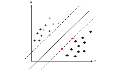
A support vector machine (SVM) was used to classify footprints. First, the GEDI L2A footprint points in the study area in 2020 were extracted, and survey data were used to label the ground object categories under the footprint points. Simultaneously, the spectral reflectance of Landsat remote sensing images at the footprint points was extracted and the vegetation index was calculated. Second, the waveform information and spectrum at the footprint point were normalized, and the sample data were randomly divided into training and verification datasets. Among them, 70% of the training data were used to train the SVM classification model, and 30% were used to verify its accuracy of the classification model. Next, the feature vectors in the training dataset were input into the SVM classification model, and GridSearchCV was used to search for the penalty coefficient and kernel function of the SVM to obtain the optimal parameters and train the optimal classification model of the footprint points. Subsequently, the producer accuracy (PA), user accuracy (UA), overall accuracy (OA), and Kappa coefficient were calculated using the validation dataset to evaluate the model. Finally, the sample data from the six subregions of the study area were extracted. The classification results for the other regions were predicted based on the data training model for each region, and the adaptability of the method was evaluated.
The importance of two types of source variables (waveform and spectrum) is calculated by using the experiment of the importance of the general classification model (Fig. 3), and multiple feature groups (Table 6) are set according to the feature source and importance to train the prediction model respectively. The evaluation of the model shows that the overall accuracy of using only one type of feature is less than 82%; however, the OA can reach 90.68 % when used together (Table 7?11). This shows that the combination of the spectral characteristics of Landsat spectral data and the waveform data of GEDI full-waveform LiDAR data improves the accuracy of land cover classification. The applicability of the method is tested across six subregions (plains, mountains, and hilly landforms) within the study area. Tables 12 and 13 demonstrate the proposed method's strong applicability. However, during the applicability test, challenges may arise due to the limited sample size and imbalanced data distribution. The model's practicality can be achieved by increasing the number of samples and ensuring a balanced dataset.
The spectral characteristics of the Landsat spectral data and waveform data of the GEDI full-waveform LiDAR data can be used to improve the accuracy of land cover classification. The overall accuracy of the combined use of spectral and waveform features is 90.68%, which can be improved by more than 8 percentage points when compared to a single feature. When the spectral characteristics of local objects are similar, the structural information provided by the waveform characteristics plays an important role in distinguishing different land cover types. Similarly, when the same types of objects with different structural characteristics or different types of objects with the same structural characteristics appear, the spectral characteristics play a key role. Additionally, data from six subregions in the dataset are utilized to test the applicability of the test model. The results indicate that the proposed method exhibits good universal applicability. Therefore, the combined use of height and spectral features from the GEDI and Landsat OLI data is beneficial for land cover classification of GEDI footprints.
黄兴, 胡旭嫣, 刘微微, 赵宏. 基于星载激光雷达与多光谱影像结合的土地覆盖分类方法[J]. 中国激光, 2024, 51(8): 0810004. Xing Huang, Xuyan Hu, Weiwei Liu, Hong Zhao. Land Cover Classification Method Integrating Spaceborne LiDAR Combined with Multispectral Images[J]. Chinese Journal of Lasers, 2024, 51(8): 0810004.


